Joshua 13: The land still to be taken, and the land already given
Read it →Joshua is old, and a great deal of Canaan is still in other hands. Verses 2-6 list what remains — the Philistine five, the Geshurites and Avvim, the Sidonian shore and Lebanon. The rest of the chapter looks east across the Jordan and records what Moses had already handed out of the kingdoms of Sihon and Og: the Arnon tableland to Reuben, Gilead and the Jordan valley to Gad, and Bashan to half the tribe of Manasseh.
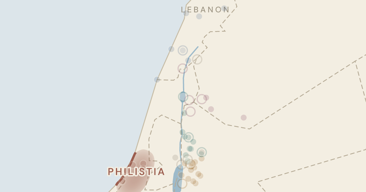
Regions on this map
Still to be taken
Verses 2-3: the five Philistine lordships from Gaza to Ekron, with the Geshurites and the Avvim, reaching south-west to the Shihor before Egypt.
A Philistine lordship on the coastal plain, still unconquered when Joshua grew old.
Today: Tel Ashdod
The one Philistine capital standing directly on the sea.
Today: Tel Ashkelon
The northernmost Philistine capital; verse 3 uses it to mark how far the unconquered coast reached.
Today: Tel Miqne
The inland Philistine capital in the Shephelah foothills, later remembered as Goliath's town.
Today: Tell es Safi
The southernmost of the five Philistine lordships and the first named in the list of land still to take.
Today: Tell Harube
The water "before Egypt" that marks the far south-western limit of the unconquered coast — read either as the easternmost branch of the Nile (31.04°N, 32.55°E) or as the Wadi el-Arish (31.15°N, 33.81°E); both lie west of this frame.
off this map to the south-west
A southern people listed with the Philistine districts, and not the Geshur of the Golan named later in the chapter. No site has been identified for them: 1 Samuel 27:8 puts them among “the inhabitants of the land from of old, as far as Shur, to the land of Egypt” — the desert margin south-west of Philistia that David raided out of Ziklag.
no site identified
The older population the Philistines displaced. No settlement of theirs is known; Deuteronomy 2:23 places them “in villages as far as Gaza” until the Caphtorim came from Caphtor, destroyed them and settled in their place.
no site identified
Verses 4-6: Sidonian country from Misrephoth-maim north past Byblos, and all Lebanon eastward from Baal-gad below Hermon to Lebo-hamath.
The northern Aphek, high on the Lebanese slopes at the source of the Adonis — not the Aphek of the Sharon plain.
Today: Afqa
"The cave" belonging to the Sidonians, somewhere in the Lebanese hills — one of the least certain names in the chapter.
Today: unidentified; best guess in the hills near Jezzine
The Phoenician city whose people held the coast Israel had not reached.
Today: Sidon (Saida), Lebanon
The valley town below Mount Hermon that marks the northern reach of Joshua's campaigns; its site is still argued over.
Today: Hasbaya
Byblos, whose people the Giblites held the Phoenician coast north of Sidon.
Today: Byblos
The mountain country whose highlanders God promises to drive out ahead of Israel.
Today: the Mount Lebanon range (point near Jezzine) (representative point)
The far northern gateway toward Hamath — the outer edge of what was promised, deep in the Beqaa.
Today: Labweh
The coastal point near the Ladder of Tyre where the Sidonian hill country ran out.
Today: Khirbet el Musheirifeh
Already given
Verses 15-23: the Medeba tableland, from Aroer on the rim of the Arnon north to Heshbon's towns, with the Jordan and the Dead Sea as its western boundary.
Reuben's southern corner post, perched on the north rim of the Arnon gorge.
Today: Arair
A plateau town of Reuben; four centuries later King Mesha of Moab set up his victory stele here.
Today: Tall Dhiban
The town that names the whole "tableland of Medeba", the open plateau at the heart of Reuben's share.
Today: Madaba
The canyon — today's Wadi Mujib — that cuts the plateau and forms Reuben's southern boundary.
Today: Wadi Mujib (representative point)
Sihon's Amorite capital and the hinge of the whole Transjordan settlement — it turns up in five verses of this chapter.
Today: Tell Hesban
A plateau town of Reuben, later reclaimed by Moab and named on the Mesha Stele.
Today: Ma‘in
The "high places of Baal" from which Balaam first looked out over Israel, allotted to Reuben.
Today: Khirbet el Quweiqiyeh
Where Israel had beaten Sihon in the open field; a Reubenite town whose site is still contested.
Today: Khirbet el Medeiyineh
A Reubenite town on the desert edge, from whose wilderness Moses had sent envoys to Sihon.
Today: Qasr ez Za’feran I
A Reubenite town on the eastern fringe of the plateau; two mounds compete for the name.
Today: Tell Jawah
An old Emim settlement on the tableland, rebuilt by Reuben.
Today: Al Qurayyat
A Reubenite town close to Heshbon, remembered by the prophets for its vines.
Today: Qarn al Qubish
"On the hill of the valley" — most likely by the hot springs on the eastern shore of the Dead Sea.
Today: Callirrhoe
Reuben's foothold at the north-east corner of the Dead Sea, where Israel had camped before crossing.
Today: Tell Azeimeh
The town by the ravine where Moses was buried, in Reuben's share.
Today: Khirbet Ayun Musa
The ridge from which Moses saw the land; its slopes fall westward into Reuben's territory.
Today: Rujm Siyaghah
Verses 24-28: Jazer, the cities of Gilead and half the Ammonite country, running up the Jordan — the border — as far as the lower end of the Sea of Chinnereth.
Sihon's kingdom stopped at the Ammonite frontier, and Gad received only "half the land of the Ammonites".
Today: Amman and its district (representative point)
The wooded highland east of the Jordan, divided in this chapter between Gad's towns and Machir's half.
Today: the Gilead highlands (point at Tulul adh-Dhahab) (representative point)
A second Aroer, this one "east of Rabbah", fixing Gad's border against Ammon; the site is disputed.
Today: Umm Sweiwineh
The first town listed for Gad, on the frontier facing Ammon.
Today: Khirbet Jazzir
A hill town marking Gad's western boundary above the Jordan valley.
Today: Khirbet Batneh
Not Judah's Debir but a northern marker of Gad's border, reached from Mahanaim.
Today: Umm ed Debar
Jacob's "two camps" on the Jabbok — the seam of the chapter, where Gad's border ends and Manasseh's territory begins.
Today: Tell edh Dhahab el Gharbi
A boundary town of Gad in the Gilead hills; probably Jal'ad, though the identification is unsettled.
Today: Jel‘ad
A Jordan-valley town of Gad on the plains opposite Jericho.
Today: Tall Iktanu
A well-watered valley town Gad had asked Moses for and then rebuilt.
Today: Tall Bleibel
Gad's land ran north up the Jordan valley as far as the southern edge of this lake — the top of the southern block.
Today: Sea of Galilee (representative point)
The valley town where Jacob had once built shelters for his cattle, now Gad's.
Today: Tell Deir Alla
The last of Gad's Jordan-valley towns, a little north of Succoth.
Today: Tell es Sa’idiyeh
Verses 29-31: from Mahanaim through all Bashan and half Gilead, with the towns of Jair and Og's two royal cities, allotted to the clans of Machir.
The wide basalt tableland north of the Yarmuk that makes up most of Manasseh's share.
Today: the Hauran plateau (point near Saham al-Jawlan) (representative point)
A small Aramean kingdom on Manasseh's north-west flank; verse 13 admits Israel never dispossessed it.
Today: the southern Golan (point at Fiq) (representative point)
The Aramean statelet beside Geshur that likewise stayed put — both are still there "to this day".
Today: the upper Hula valley (point at Tel Abel Beth Maacah) (representative point)
The far eastern corner of Bashan, on a volcanic cone above the desert road.
Today: Salkhad
One of Og's two royal cities, later held by the clans of Machir.
Today: Tell Ashtara
Where Og's army was destroyed; Bashan's second capital, also given to Machir.
Today: Daraa
The "villages of Jair", sixty Bashan settlements held by one Manassite clan.
Today: northern Gilead and Bashan (point at Qamm) (representative point)
Places the chapter uses to fix a border or a vantage point, or names only in passing, rather than to allot.
Named once, only to say where the Shihor runs; the country itself lies far beyond this frame.
off this map to the south-west
The snow-capped massif that anchors the northern end of the Transjordan allotment.
Today: Mount Hermon
The river these two and a half tribes settled beyond, and the western border of both Reuben and Gad.
Today: Jordan River (representative point)
Named for the five Midianite chiefs killed alongside Sihon; Midian itself lies far to the south in north-west Arabia.
off this map to the south
The Ammonite capital — modern Amman — used here only to place Gad's eastern Aroer.
Today: Amman
Named in the closing verse to fix the plains of Moab — "beyond the Jordan of Jericho, eastward".
Today: Tell es Sultan
The plains of Moab, opposite Jericho, where Moses had made this whole allotment.
Today: the Jordan valley plain opposite Jericho (representative point)
Joshua 13, verse by verse
- Joshua 13:2This is the land that yet remains: all the regions of the Philistines, and all those of the
- Joshua 13:3(from the , which is east of , northward to the boundary of , it is counted as Canaanite; there are five rulers of the Philistines, those of , , , , and ), and those of the ,
- Joshua 13:4in the south, all the land of the Canaanites, and that belongs to the , to , to the boundary of the Amorites,
- Joshua 13:5and the land of the , and all , toward the sunrise, from below to ,
- Joshua 13:6all the inhabitants of the hill country from to , even all the Sidonians. I myself will drive them out from before the people of Israel. Only allot the land to Israel for an inheritance, as I have commanded you.
- Joshua 13:8With the other half of the tribe of Manasseh the Reubenites and the Gadites received their inheritance, which Moses gave them, beyond the eastward, as Moses the servant of the LORD gave them:
- Joshua 13:9from , which is on the edge of the , and the city that is in the middle of the valley, and all the tableland of as far as ;
- Joshua 13:10and all the cities of Sihon king of the Amorites, who reigned in , as far as the boundary of the ;
- Joshua 13:11and , and the region of the and , and all , and all to ;
- Joshua 13:12all the kingdom of Og in , who reigned in and in (he alone was left of the remnant of the Rephaim); these Moses had struck and driven out.
- Joshua 13:13Yet the people of Israel did not drive out the or the , but and dwell in the midst of Israel to this day.
- Joshua 13:16So their territory was from , which is on the edge of the , and the city that is in the middle of the valley, and all the tableland by ;
- Joshua 13:17with , and all its cities that are in the tableland; , and , and Beth-,
- Joshua 13:18and , and , and ,
- Joshua 13:19and , and , and on the hill of the valley,
- Joshua 13:20and , and the slopes of , and ,
- Joshua 13:21that is, all the cities of the tableland, and all the kingdom of Sihon king of the Amorites, who reigned in , whom Moses defeated with the leaders of , Evi and Rekem and Zur and Hur and Reba, the princes of Sihon, who lived in the land.
- Joshua 13:23And the border of the people of Reuben was the as a boundary. This was the inheritance of the people of Reuben, according to their clans with their cities and villages.
- Joshua 13:25Their territory was , and all the cities of , and half the land of the , to , which is east of ,
- Joshua 13:26and from to and , and from to the territory of ,
- Joshua 13:27and in the valley , , , and , the rest of the kingdom of Sihon king of , having the as a boundary, to the lower end of the , eastward beyond the .
- Joshua 13:30Their region extended from , through all , the whole kingdom of Og king of , and all the , which are in , sixty cities,
- Joshua 13:31and half , and , and , the cities of the kingdom of Og in . These were allotted to the people of Machir the son of Manasseh for the half of the people of Machir according to their clans.
- Joshua 13:32These are the inheritances that Moses distributed in the plains of , beyond the east of .